

Background
Sabarmati river has been an integral part in the life of Ahmedabad since the time the city was founded in 1411 along the river banks. Besides being an important source of water, it provided a backdrop to cultural and recreational activities. During the dry seasons, the river bed became a place for farming. With time it also offered place for various informal economic activities, and the river banks were used by informal squatter settlements.
Gradually, however, the intensive uses took their toll on the river. Untreated sewage flowed into the river through storm water outfalls and dumping of industrial waste posed a major health and environmental hazard. The river bank settlements were disastrously prone to floods and lacked basic infrastructure facilities. Lacklustre development took shape along the riverfront. Such conditions made the river inaccessible and it became a virtual divide between the two parts of the city. Slowly, the city turned its back towards the river.
There had been a long-standing acknowledgement that the riverfront could be turned into a major urban asset from its undesirable state. Proposals to achieve the same have been made since the 1960s and it was finally in 1998 that this multi-dimensional project was envisioned and undertaken by the city.
Sabarmati
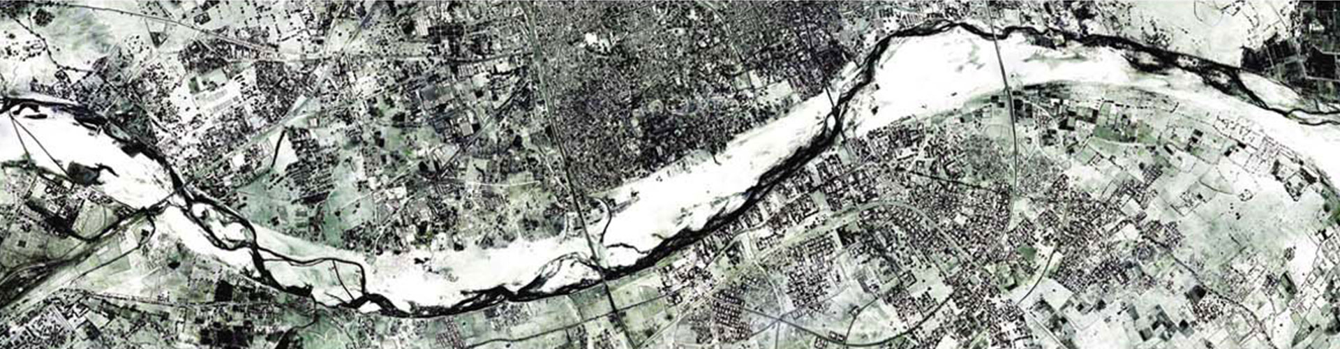
The Sabarmati River is a monsoon-fed river that flows north-south through Ahmedabad, bisecting the city into its western and eastern halves. It has been an integral aspect of Ahmedabad city since its foundation. Initially, the river was the city’s prime source of water. Today, water is supplied from many distant sources. Nonetheless, the river continues to be important. It has provided space for cultural and recreational activities along the banks. Mahatma Gandhi set-up his ashram along the banks of the river and during the freedom movement, the Salt March began from here. The wide, oft-dry riverbed and riverbanks were used more extensively to launder clothes and to dye textiles. During the dry seasons, the river bed was used for farming. It also became a venue for other informal economic activities such as the ‘Ravivari’- Sunday flea market. Gradually, many of the city’s migrant and poor population began to live in informal settlements on the river banks.

All these uses and abuses along with rampant urban growth led to the Sabarmati River becoming polluted, abused and neglected. The riverfront became characterized by unimaginative and unplanned development. Property owners along the banks, who could afford it, built their own retaining walls to protect their properties from flood erosion. The poor citizens living along the riverbanks in slums were disastrously flood prone and lacked basic infrastructure facilities. Sewage-contaminated storm water outfalls and the dumping of industrial waste in the river posed a major health and environmental hazard. In addition to the declining ecological health, the river itself became inaccessible to the majority of the city’s residents. Owing to private ownership of most riverside land and the informal settlements, there were very few public access points to the river. By the 1970s, the bridges were the only places from where citizens could enjoy the expanse of the river running through the heart of the city.

Regional Geography
Sabarmati is one of the major rivers in the western region of India. It is a monsoon-fed river that originates in the Aravalli hills of Rajasthan and has basin areas in Rajasthan and Gujarat. The river after traversing a distance of 400km meets the Gulf of Cambay. It flows mostly through Gujarat state except in its initial length of 9.5km. Various tributaries, important amongst which are the Hamav, Guhai, Hathmati, Khari, Meshwo, Mazam, Watrak, Mohar and shedhi, meet the main river. Gandhinagar, the capital of Gujarat state and Ahmedabad are located on the banks of this river. There are several reservoirs on Sabarmati and its tributaries namely- Dharoi dam, Hathmati dam, Harnav dam, Guhai dam, Meshvo reservoir, Meshvo pick-up weir, Mazam dam and Watrak dam. The last four schemes are located on tributaries meeting the main river downstream of Ahmedabad. The Dharoi dam is located on the main river.
At Ahmedabad, the river encompasses a total catchment area of 10,370 sqkm, out of the total basin area of 27,820 sqkm. Pre-project, the width of the river varied from 300m to 425m. Until Dharoi dam was built in 1976 (approximately 200km upstream of Ahmedabad) the Sabarmati was prone to severe and frequent flooding. The floods in the recent past that Ahmedabad has seen are discharges from Dharoi Dam- announced twelve hours in advance of the released water arriving in Ahmedabad. Vasna Barrage was built downstream of Ahmedabad in 1976 for water retention in Sabarmati and to divert water for irrigation through Fatehwadi Canal. The Narmada Canal, which crosses the river a few kilometres upstream from the city, is part of a larger irrigation network.
Previous Proposals
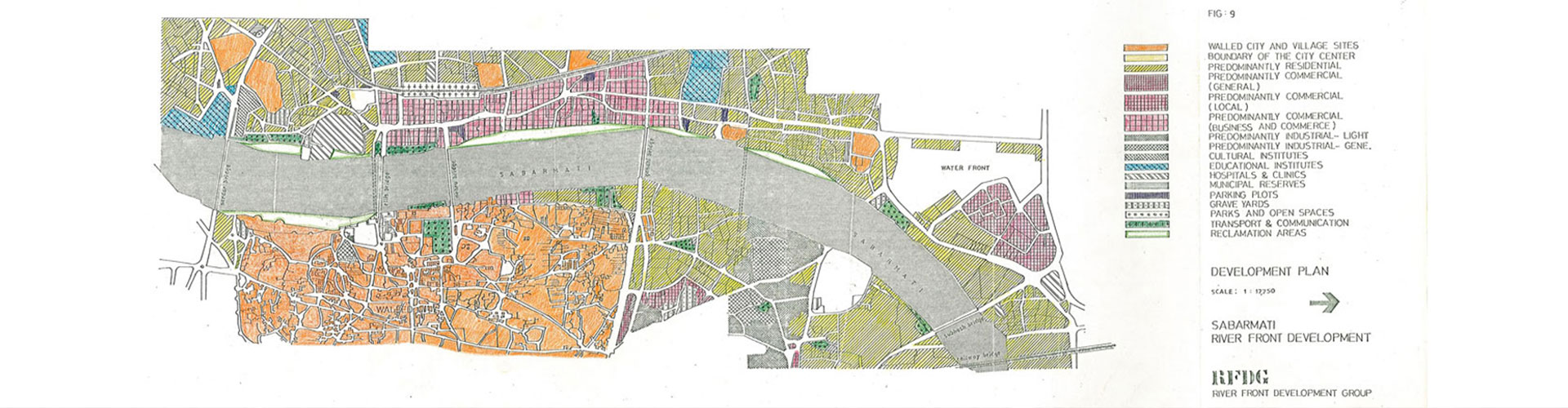
Efforts at riverfront development are not new to the Sabarmati River. Way back in the 1960s, a French architect Bernard Kohn, who was then residing in Ahmedabad (in collaboration with Kamal Mangaldas, city-based architect, Anil Bakeri, an engineer and a few others) was the first to propose the development of a portion of the Sabarmati Riverfront with a mix of commercial, recreational and residential development along both the banks from Gandhi Bridge to Sardar Bridge. The proposal called for reclamation of about 30 hectares, of which a part was to be sold or leased for commercial development. In 1976, a group of local professionals came together as the River Front Development Group to propose an incremental approach to creating a public riverfront. Thus, there has been a long-standing acknowledgment that the riverfront can be turned into a major urban asset from its present undesirable state.

Chronology
-
1964
Bernard Kohn, French architect residing in Ahmedabad creates a proposal for Integrated Planning & Development of Sabarmati Riverfront, calling for reclamation of 30 hectares of land. -
1966
Kohn’s proposal is claimed technically feasible by Government of Gujarat after technical studies are completed. -
1976
Riverfront Development Group proposes an incremental approach to reduce the need for initial capital investment. -
1992
National River Conservation Plan proposes construction of sewers and pumping stations at the periphery of the city as well as upgrading of existing sewage treatment plants.
Project Inception
It has long been acknowledged that appropriate development of Ahmedabad’s riverfront and the building of adequate infrastructure can turn the Sabarmati River into a major asset for the city and significantly improve the quality of life for all sections of its citizens. The Sabarmati Riverfront has the potential to create a singular identity for the city, bring people closer to water, bring back focus to the city center, and create city level social infrastructure and recreation facilities. It was with this aim that the following developments took place.
-
1997
Ahmedabad Municipal Corporation (AMC) sets up a Special Purpose Vehicle - Sabarmati Riverfront Development Corporation Limited (SRFDCL) to manage the construction and development of the project -
1997
Environmental Planning Collaborative, under the leadership of Dr. Bimal Patel (EPC) prepares the feasibility report for the project, and subsequently, SRFDCL appoints HCP Design and Project Management Pvt. Ltd. to lead the architectural, structural and urban design aspects of the project.
The Sabarmati Riverfront Development has been envisaged as a comprehensive development of approximately 11 kilometres of length on both the banks of the Sabarmati River encompassing all its potentials as primary goals. The project approach is to bring about an overall environmental improvement, social upliftment and sustainable development along the Riverfront.
Feasibility Report
The feasibility report was prepared by Environmental Planning Collaborative (EPC) for the Sabarmati Riverfront Development Proposal in 1998. It included technical assessments and strategies for various aspects of the project, namely-
- Physical features of the river
- River hydraulics
- Land reclamation and embankments
- Land ownerships
- Water retention
- Ground water recharge
- Land use and road network
- Infrastructural services
- Resettlement & rehabilitation
- Implementation strategy
- Project costs and revenue potential
- Financing, structure of the SRFDCL, and
- Development management
Timeline of Sabarmati Riverfront Development Project
A timeline of the history of the Sabarmati Riverfront Development Project.